
Introduction
The fibre optic network is fascinating. Especially in a market like Nigeria, transitioning between wireless, 2G, 3G (and all the Gs), fibre optics, and then Elon Musk’s Starlink, and places in Japan are toying with 10G.
Managing these telecom assets is very important. As a professional in operations technology, I am fascinated by how GIS can be used to manage these Telecoms assets, draw analysis with the data mapped and captured and assist in decision-making across the board – from executives to field technicians.
What is FTTH and Why Does it Matter?
Optical fiber technology works by carrying data as pulses of light, delivering virtually zero signal degradation over distance.
Fibre-to-the-Home (FTTH) is the gold standard of broadband delivery — a continuous optical fiber pathway running from the service provider’s base, through distribution networks, all the way into the subscriber’s premises. So in an area like Ikeja GRA, Lagos, where demand for reliable connectivity is intense and road infrastructure is relatively well-planned, FTTH deployment is both technically feasible and commercially justified. But deploying fiber is only half the battle — managing it spatially is where real operational excellence begins.
“Every strand of glass buried beneath or spliced in a cabinet on the Street is a spatial asset — it has a location, a condition, a capacity, and a relationship to every other asset in the network.”
— Okemefuna Nwabudike
The FTTH Architecture: Source to Home
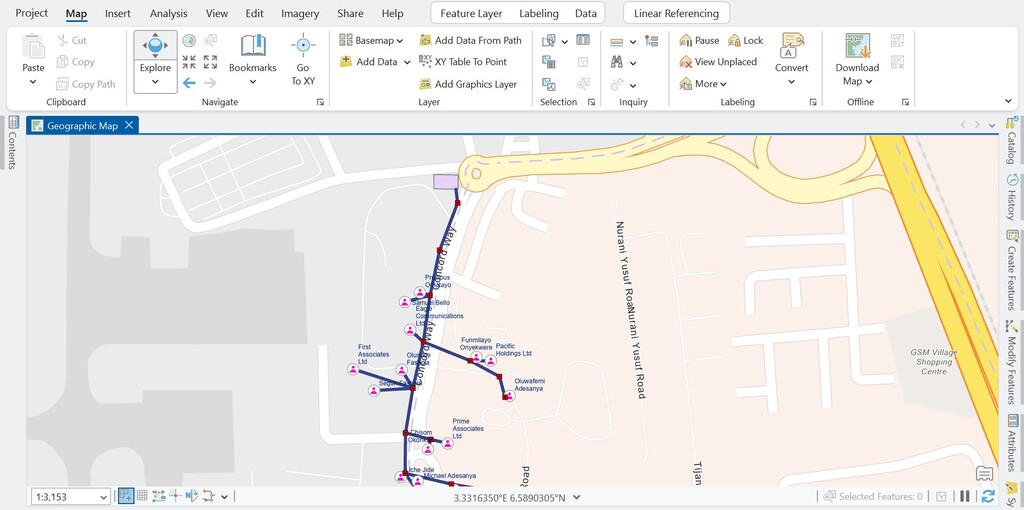
A well-designed FTTH network follows a hierarchical topology. The signal originates at the Central Office (CO) or Optical Line Terminal (OLT), typically located at a major exchange facility. From there, feeder cables — high-strand-count trunk fibres — run underground along primary roads to reach the neighbourhood boundary.
GIS as the Backbone of FTTH Asset Management
Geographic Information System is not a luxury in fiber management — they are the operational foundation. A robust GIS platform enables engineers and planners to maintain a living digital twin of every network element: its precise GPS coordinates, installation date, splice loss readings, splitter occupancy, and maintenance history.
In practice, this means every FDH cabinet in Ikeja GRA is a geo-referenced point feature with linked attribute tables containing port utilization, cabinet serial numbers, and maintenance schedules. Feeder and distribution cables are polyline features with embedded attributes for cable type, strand count, depth of burial, and route length. Drop cables are linked to parcel boundary data, enabling automatic subscriber association the moment an address is geocoded.
GIS Operational Value: Beyond the Map
The real power of GIS in FTTH management emerges in four operational domains. They include
1) Network planning — spatial analysis of population density, road access, and existing duct routes in Ikeja GRA allows planners to optimize cable routing, minimize civil works, and maximize homes-passed per kilometer of fiber.
2) Fault management — when a subscriber on Concord Way reports signal loss, a GIS-linked OSS can spatially query which FAT and FDH serve that address, instantly narrowing the fault domain to a specific splice point or splitter port.
3) Capacity management — live occupancy data visualized on a GIS dashboard reveals which FDH cabinets are approaching full utilization, triggering proactive expansion before service is impacted.
4) Civil works coordination — excavation permits, utility clash detection, and as-built survey updates are all managed spatially, reducing the risk of accidental cable cuts.
“A fibre network without GIS is infrastructure without intelligence. The map is not just a record — it is the decision engine.”
— Okemefuna Nwabudike
Conclusion:
FTTH deployment in dense urban environments like Ikeja GRA demands more than good engineering — it demands spatial intelligence. GIS transforms a collection of buried cables and street cabinets into a managed, query-able, and analytically powerful asset network. That is the discipline of spatial asset management — and it is what separates reactive maintenance from proactive infrastructure governance.
This is not a real project, but with my experience in asset management and GIS, like in my previous post, I built the data to demonstrate how effective the telecoms business, especially with Fibre Optics as a winning asset management structure.
#gis #assetmanagement #telecom #fibreoptics #okemefuna #okemefunanwabudike